

The Drainage System
Drainage system which consists of rivers and streams in a relief feature of a land, plays a crucial role in shaping the Earth’s surface by forming valleys, plains, and basins through erosion and deposition. It reflects the geological structure and slope of the region it flows through. A drainage system not only shapes the landform, contributing to its beauty, but also caters in developing regional vegetation, local climatic condition and life unsustainability – both botanical and zoological, by carrying minerals and life supporting elements.
Benefits of a drainage system do not close here, it is one of the key resources, that is water, of an economy of country. From enriching soil and providing irrigation for agriculture, fishery, transportation of resources and humans and water supply to industries, to providing drinking water to urban and rural populace. Even in ancient times, most civilisations evolved along the drainage system of a region such as Indus Valley civilisation on Indus river system, Sumerians or Mesopotamian on Tigris and Euphrates, Egypt Civilisation on Nile rivers are to name a few. Over time, culture, civilisation and societies flourished along the drainage system, this evolution of drainage system reflects human ingenuity in harmonising with nature.
Let us study how drainage flow occurs or shapes the geographical feature of a landform.
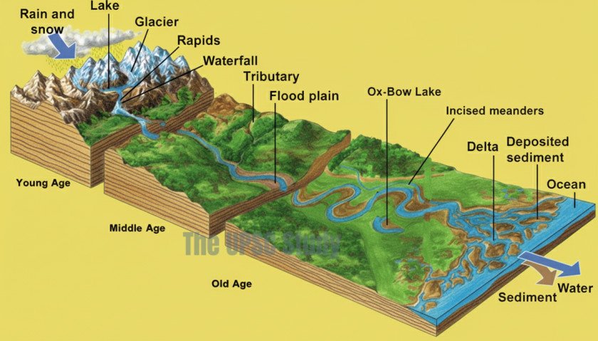
Table of Contents
What is Drainage System?
The term drainage refers to the flow of water in distinct and well-shaped channels and forming a network in a form of river-system consisting a head-water or sources, the course of river and the distribution in a form of tributaries and distributaries which collectively called Drainage System.
The drainage system of a region describes how surface water flows across the land, primarily through rivers and their basins. It examines the network of streams and the paths they follow to transport water within a specific area. Several factors influence this system, including the land’s slope or topographic slope or gradient, geological features like folds and faults, composition of the rocks (geological structure), climatic and hydrological variations, water volume-the catchment area, and flow velocity, which together determine the drainage pattern or the flow pattern of the river. In India, the surface runoff is managed by numerous rivers, both large and small, that together form an extensive and interconnected network of drainage systems.
A head-water or source is place where a river originates, it can be a lake or stream or glacier or a spring.
A river gathers water form other streams, headwater, or groundwater in a defined region called its catchment area or watershed which flows into a common outlet such as a larger river, lake, or sea.
The total collected water drained by a river and its tributaries is known as a drainage basin, thus drainage basin is synonymous to catchment area but in collective sense. Drainage basin can be categorised into – Endorheic, Exorheic and Arheic.
Exorheic or Open drainage system: the drainage basin run-off into a larger body like sea or ocean. Examples, all the major river in India of Himalayan and Peninsular river systems.
Endorheic or Closed drainage system: the water drains from the basin into a larger catchment area, retaining the water and no outflow to other external bodies of water such as sea and oceans. Water drainage in such regions flows into permanent or seasonal lakes and swamps, where balance is maintained mainly through evaporation. These endorheic basins are also known as closed basins, terminal basins, or internal drainage systems. Examples, Lower Chambal Basin, Sambhar basin (Mendha, Runpangarh, and Kharian), Loktak Lake basin, Rann of Kutchh (luni river), Thar basin (Ghaggar-Hakra), Tsokar and Tsomoriri Lakes, etc. Other good examples are drainage systems pouring into Aral and Caspian sea.
Arheic or arid drainage system: In desert regions, low water inflow combined with intense solar evaporation greatly limits the development of complete drainage systems. In extreme conditions, where no distinct drainage system exists, the basin is termed arheic. Example, endoheric rivers like Luni river dries in Runn of Kuttch, ghaggar-hakhra river dries up in Thar desert.
A watershed divide is the boundary in a form of ridgelines that separates one drainage basin or river run-off from another. Large rivers have extensive river basins, while smaller streams or rivulets have smaller watersheds. River basins are larger in size compared to watersheds.
Drainage system, based on the availability of headwater, can be perennial and non-perennial. A perennial river is one which has continuous supply of water from the headwater and other sources and pour into its drainage basin throughout the year, on the contrary a non-perennial rivers have seasonal headwater source and their drainage basin is innundated only a certain period of time and dry or little water in the other time.
Perennial rivers are mostly fed by glacial water, alongwith rainwater, and have high volume and flow (such as all the Himalayan rivers); whereas non-perennials are dependent on seasonal rain, and under-ground springs source in some cases, and have low volume and flow such as peninsular rivers in India.
Forces influencing the drainage system
The course of a drainage system or river is result of its underlying dominant landform.
A landform is formed based on natural forces which can be:
Endogenic force which is a result of movement of continental rocks or isostatic movement and change in sea level or Eustatic force, due to folding (compressional) and faulting (decompression) of rocks, and tectonic movement causing landform to have upward movement, or emergence, or downward movement, or submergence, forming orogenic features like mountains, plateau, rift-valleys (horst and graben), canyons or gorges, etc.
Exogenic force is a result of weathering-lithification, and erosional-depositional features.
- Weathering is gradual disintegration and decomposition of rocks or mass-wasting due to chemical, physical or biological factors, where as lithification is gradual addition of layers in rocky feature. It is in-situ or on site process, which is the process occurring in the acting and local site, where controlling factors are within the rock profile such as gravity, inclination, chemical composition of rock salts, change in climatic conditions, flora and fauna on the rock surface, etc.
- On the contrary, erosional-depositional feature is ex-situ or outside force. Erosion is removal of layers or degradation by external factors like water or air, and deposition is the accumulation of geomorphic agents like sand, water, soil, etc. Both erosion and deposition are mobile process as the movement is not limited to the local rock profile and can transport to a different and newer landform other than the acting landform.
The weathering process is further assisted by erosional process by geomorphic agents like air, water, glacier, ice, soil, etc. Thus, based on geomorphic agents the erosional landform can be classified as- Fluvial landform- Erosion due to running water.
- Aeolean landform- Erosion due to wind or air.
- Glacial landform– Erosion due to glacier movement.
- Karst topography– erosional feature due to ground water system.
All these features, especially the fluvial and glacial landforms are results and causes of a course of river system. The endogenic forces determine the gradient or inclination of a river course (topographic slope), whereas exogenic forces determine the movement of a river course, in the drainage pattern.
The basis of a Drainage System
The study of drainage system, of its features and formation, is based on two ways:
- The Genesis of the river drainage system : The formation and entire course of river system from the source of the river to the final course before entering a sea or dying.
- The flow pattern (drainage pattern) of the river drainage system: how the river originated from the source and forming pattern of its flow cutting through the rocks. The movement and trials of the river.
The Genesis of the river drainage system
Based on the course of the river
The genesis of a river, based on course of river, can be divided into upper or youth course, middle or mature course and lower or old course.
- Upper Course of River:
- Steep-sided V-shaped valleys – gorges and canyons
- Rapids and waterfalls
- Potholes
- Interlocking spurs
- Meanders
- Middle Course of River:
- Wider, shallower U-shaped valleys
- Alluvial fans
- Meanders and oxbow lakes
- Lower Course of River:
- Wide, flat-bottomed valleys
- Flood plains
- Natural levees
- Meanders and oxbow lakes
- Braided streams
- River deltas and estuaries
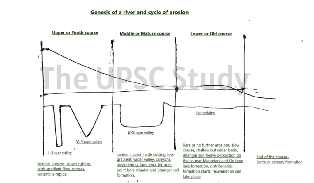
1. Youthful Stage (Upper Course)
During the youthful stage, the river system is in its initial development phase. The network of the drainage system is poorly integrated, and only a few streams exist. The landscape displays steep gradients and pronounced relief. Valleys formed in this stage are typically narrow, deep, and V-shaped, often resembling gorges or canyons. Floodplains, if present, are very narrow or almost absent. Intervening divides are wide and flat, frequently containing marshes, swamps, and small lakes.
The river actively lengthens its course through headward erosion, gradually extending its basin. The dominant erosional force is vertical erosion, which deepens the valley through processes like pothole drilling. Occasionally, the river meanders across broad uplands, and these bends may become entrenched over time due to downward cutting. Resistant rock layers can give rise to rapids, waterfalls, and cataracts, depending on their hardness and arrangement. The phenomenon of river capture, where a river with a steep gradient diverts the flow of another with a gentler gradient, is a distinctive feature of this youthful phase.
Valley Formation
Valleys evolve in shape and dimension as the erosional cycle advances. In the youthful stage, V-shaped valleys predominate, created by the river’s powerful downward cutting. These valleys are deep and narrow, with sides that slope directly into the stream channel. Over time, lateral erosion becomes more pronounced, widening the valleys during the mature phase and eventually converting them into broad, shallow valleys with gentle, concave slopes during the old age stage.
Two special types of deep V-shaped valleys are recognised:
- Gorges – deep valleys with steep, almost vertical sides, uniform in width from top to bottom.
- Canyons – valleys with step-like sides, generally wider at the top and formed mostly in horizontally bedded sedimentary rocks (e.g., the Grand Canyon of the Colorado River).
Both are results of persistent vertical erosion, often occurring in regions with hard or arid rock formations. In such terrains, rivers frequently develop interlocking spurs, winding around resistant rock masses.
Rapids, Cataracts, and Waterfalls
Where rivers traverse alternating layers of hard and soft rock, differential erosion occurs. The soft layers erode quickly, while hard layers remain as obstacles, producing rapids—sections of a river with a sudden increase in gradient. Larger drops of water over resistant strata form cataracts (e.g., Niagara Falls), and vertical plunges create waterfalls.
Waterfalls may form in two ways:
- Normal waterfalls – resulting from lithological variations in rock resistance.
- Minor or rejuvenation waterfalls or Knick Points – formed when tectonic uplift or sea-level change interrupts the normal erosional cycle. Unlike the normal water falls, such features of knick point usually observed in the river’s mature course. Example, Hudru falls at Ranchi is an example of Knick points due to rejuvenation of river Subarnarekha at Chota Nagpur Plateau (Ranchi Plateau).
Potholes and Plunge Pools
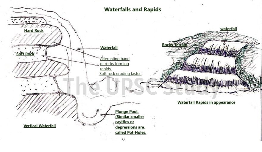
Small, circular depressions called potholes are carved into the rocky beds of rivers through mechanical drilling by swirling pebbles and sediments caught in water eddies. These features are common near the bases of waterfalls and in coarse-grained rocks like granite or sandstone. Over time, continued abrasion enlarges these depressions. Larger and deeper versions of potholes, formed by the turbulent impact of falling water, are known as plunge pools.
2. Mature Stage (Middle Course)
In the mature or middle stage, the river network becomes extensive and well integrated. The overall slope of the land decreases, reducing river velocity and lessening vertical erosion. Lateral erosion now dominates, leading to significant valley widening. The valleys evolve from narrow V-shapes into broad U-shaped valleys with straight side slopes and wide floors. Gorges and canyons give way to broad alluvial plains.
As lateral erosion progresses, interstream divides narrow due to continuous back wasting, eventually forming sharp ridges. The river’s longitudinal profile becomes graded, meaning the rate of erosion, transportation, and deposition are in equilibrium with its base level. Extensive floodplains develop as sediments accumulate along the river’s banks, and natural levees form during flooding when coarse materials settle near the channel margins.
The mature river begins to form meanders—bends in the channel created by the differential flow of water. These bends can evolve into oxbow lakes as meander loops are cut off during floods. With the decline in slope, rapids and waterfalls disappear, and deposition becomes more common than erosion.
River Terraces
River terraces are remnants of former floodplains left stranded when a river cuts down into its valley floor. They can be bedrock surfaces or alluvial terraces composed of sediments. Terraces often occur in multiple levels, reflecting successive phases of downcutting caused by factors such as regional uplift or sea-level changes.
Types of terraces:
- Paired terraces: Occur on both sides of the river at equal elevation, signifying uniform downcutting.
- Unpaired terraces: Found at unequal heights, typically formed when erosion is uneven due to gradual uplift or variable flow conditions.
Alluvial Fans and Cones
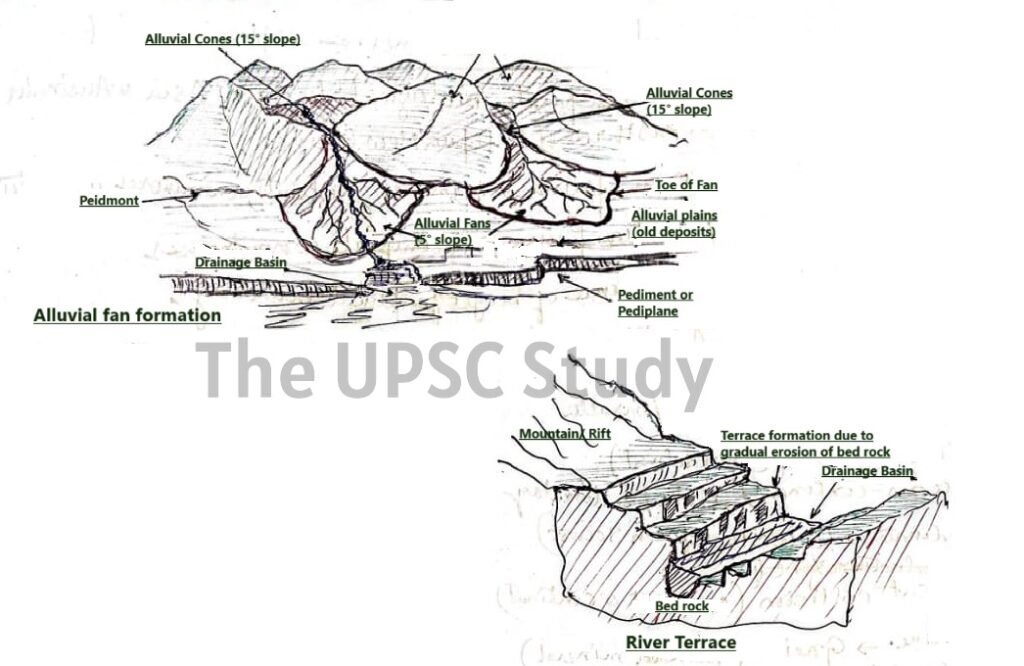
Where a river emerges from a steep mountain front onto a gentler plain, its velocity decreases sharply, leading to deposition of sediments in a cone- or fan-shaped accumulation called an alluvial fan. These deposits are coarser near the apex (close to hills) and finer toward the edges. Alluvial cones have steeper gradients than fans. In humid climates, fans are broad with gentle slopes, whereas in arid regions, they are high and steep. The Himalayan Bhabar zone (coarsed alluvial at the piedmont, along the fans) and Tarai zone (marshy and water logged soil after the Bhabar) are a notable example formed by such fans composed of coarse sediments like boulders, gravels, and sands.
Floodplains, Natural Levees, and Point Bars
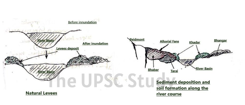
As rivers overflow their banks during floods, sediment deposition creates floodplains, which are extensive flat surfaces of fine alluvial materials (sand, silt, clay). The coarser deposits form near the channel, while finer sediments settle farther away, producing natural levees – low ridges along the riverbanks that gradually slope outward. These features provide some natural protection against future flooding. Khadar – young alluvial at new formed flood plains, and Bhangar – Old alluvial deposited on the older floodplain and away from the river stream, soil are the features of the floodplains which are fertile and very good for cultivation.
Point bars or meander bars are formed on the inner convex sides of meander loops, where slower-moving water deposits sediments. Simultaneously, erosion occurs on the outer concave side (cut bank). The interplay between erosion and deposition results in the lateral shifting of the meandering channel.
Oxbow Lakes and Meanders
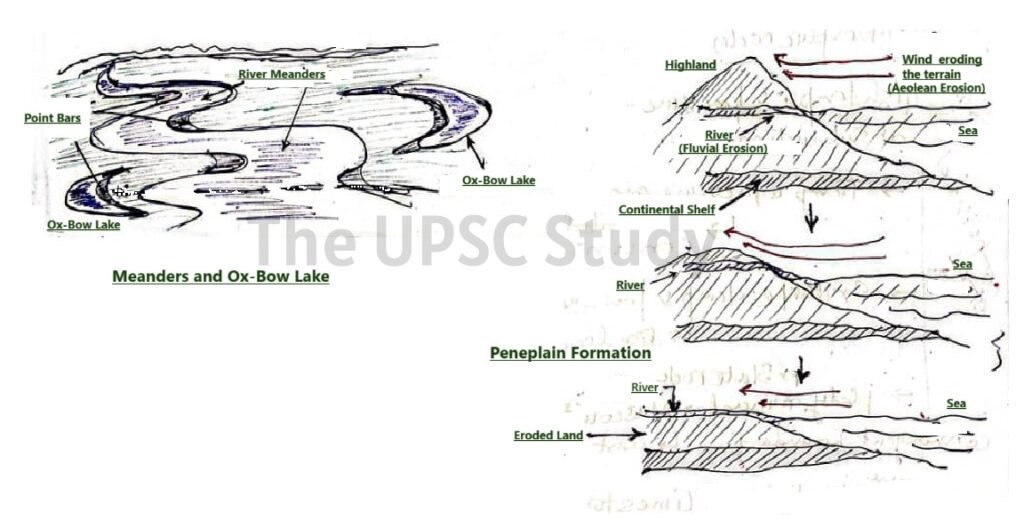
Oxbow lakes develop when growing meanders become so pronounced that during floods, the river cuts a new, shorter channel, isolating the meander loop. The abandoned loop retains water, forming a crescent-shaped lake.
Meanders arise due to differences in velocity across the river channel—faster flow on the outer bend leads to erosion, while slower flow on the inner bend causes deposition.
Incised Meanders form when meandering rivers experience uplift, forcing them to cut downward into bedrock. Two types exist:
- Ingrown meanders: Develop gradually with continued lateral erosion, producing asymmetrical cross-sections.
- Entrenched meanders: Form rapidly due to sudden uplift, producing deep, symmetrical gorge-like valleys.
3. Old Stage (Lower Course)
In the final, old-age stage, the river reaches near base level, and erosion is minimal. The gradient is gentle, tributaries become fewer, and lateral erosion dominates completely. The inter stream divides are nearly eroded away, creating a vast, low-relief plain. The valleys become extremely broad and flat, while sediments are extensively deposited due to the reduced transporting capacity of the river.
This stage is marked by wide floodplains, braided streams, and expansive river deltas and estuaries. Rivers meander freely, forming numerous oxbow lakes and levees. The overall landscape is converted into a peneplain, a nearly level plain interspersed with isolated residual hills called monadnock or inselberg, which are remnants of harder rock masses that resisted erosion.
Graded Profile
A river’s longitudinal profile represents its elevation from source to mouth. When equilibrium is achieved between erosion, transportation, and deposition, the river is said to have a graded profile. This state reflects dynamic balance, where the river neither gains nor loses energy over time, maintaining a steady capacity for sediment transport.
Base Level
The base level defines the lowest point to which a river can erode its channel. The ultimate base level is typically sea level, though temporary or local base levels can exist where tributaries join larger rivers or reservoirs. Once a river attains this level, vertical erosion ceases, and deposition becomes dominant.
Rejuvenation
Rejuvenation occurs when the base level falls due to tectonic uplift, sea-level decline, or crustal rebound, restoring the river’s erosional power. The river begins renewed downward cutting, restarting the cycle and carving deeper valleys. This process originates at the mouth and migrates upstream through headward erosion. Rejuvenation produces distinct landforms such as incised meanders, knick point waterfall and river terraces, representing renewed erosion into previously deposited floodplains.
Deltas
A delta is a fan or triangular-shaped depositional feature formed where a river meets a standing body of water—such as a lake or sea—and abruptly loses velocity. As sediment load exceeds the transporting capacity, materials accumulate at the mouth, building the land outward. Deltas consist of multiple distributary channels that branch from the main stream to deliver sediment into the basin.
Deltas form where:
- Sediment supply is abundant, and
- Marine processes (waves, tides, currents) are too weak to disperse the sediments.
The size and morphology of a delta depend on the drainage basin characteristics, sediment load, rainfall, vegetation, and tectonic stability. Many rivers of the world, from large ones like the Ganges-Brahmaputra to smaller streams, end in well-developed deltas.
Based on formation of drainage system
The genesis of a river can be based on formation of the drainage system and flow pattern of its network of streams and rivers shaped by topography like folding and faulting of bedrocks causing upliftment and slipping of terrain, composition of rocks and geological structures. Their courses are influenced either by:
- Initial slope/topography (surface-driven) – due to folding and faulting
- Differential erosion of bedrock (structure-driven)
Based on formation of river:
Some streams follow the original surface slope, while others are controlled by erosion along weaker rocks. Based on these influences, streams are classified into:
- Concordant Drainage system
- Discordant Drainage system
Concordant Drainage Systems
Terrains formed before the river drainage which adjusted to regional geological structures.These rivers align with the original slope and geological structure. They typically have low flow rates and adjust to pre-existing terrain. These usually form at old landforms, continental platforms and rift valleys (horst and graben). Rivers which can be used as examples are majorly peninsular rivers- Godavari, Krishna, Cauvery, Mahanadi, tec and rivers running between rift valleys such as Narmada and Tapi (between Vindhya and Satpura range), and Damodar (between Hazaribaug plateau and Chotanagpur plateau). However, such pattern can be seen in the mature and old course of Himalayan rivers as well.
1. Sequent Drainage Systems
Follow already developed regional slope and and are well adjusted to regional geological structures.
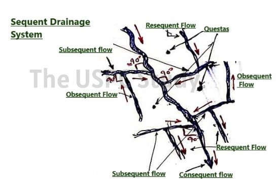
- Consequent Streams
- Originate directly from the initial topography (initial slope of the land surface).
- Flow along natural slope.
- Valleys deepen through headward erosion.
- Commonly form dendritic, parallel, or trellis patterns.
- Major rivers originating from elevated areas such as Godavari, Krishna, and Mahanadi began as consequent streams.
- Subsequent Streams
- Develop after the main consequent stream.
- Flow at right angles to the main consequent stream ( in trellis pattern).
- Follow weaker rock zones like faults or joints, along anticlines, ridges, or strike lines of rocks.
- Resistant ridges between strike valleys are termed hogbacks or cuestas.
- Example: Chambal, Sind, Ken, Betwa joining Yamuna at right angle (trellis).
- Obsequent Streams
- Flow opposite to the main consequent stream.
- Formed by structural adjustments post valley development.
- jhese Join subsequent streams at right angles (in rectilinear and trellis pattern) in a direction opposite to the main consequent stream.
- Example: Tributaries of Narmada, Tapi and streams from northern Himalayas.
- Resequent Streams
- Streams flowing in the same direction as the main consequent river but formed due to a new base level after relief inversion.
- Join the subsequent streams but align with main consequent stream.
- Found in the tributaries of peninsular drainage system such as Krishna and Godavari basins.
- Flow opposite to the obsequent streams which also join the subsequent streams.
Trellis Drainage Pattern is formed by the combination of consequent, subsequent, obsequent, and resequent streams.
The subsequent and obsequent usually join as tributaries to the consequent stream, whereas resiquent usually as distributary.
Discordant Drainage Systems
These rivers cut across geological structures and often predate the terrain. Terrain is formed by rivers due to erosion. Rivers have high flow rate and may have existed prior to the genesis of the relief. These form on new landform developed which are usually formed later than the actual river course, or new fold mountains, new alluvial soils or soft sedimentary rock surfaces. Rivers that can be exampled are rivers originating from Himalayas and North_Eastern rivers of India, as these rivers cut through the soft sedimentary rocks of the Himalayas.
1. Insequent Streams
Do not follow regional slope or structure. Streams that cut across geological structures, showing no conformity with regional slopes. These may be antecedent or superimposed depending on formation history.
- Antecedent Rivers
- If a river has been able to maintain original direction of flow despite tectonic uplift or folding of land across their course.
- Down-cutting rate exceeds uplift rate, the river cuts through rising terrain faster than the upliftment of the basement rocks.
- Formation of deep gorges and entrenched valleys through resistant rock masses.
- Example:
- Indus and Sutlej (cut through Himalayas)
- Brahmaputra (originates in Tibet)
- Ganga, Ghaghara, Chenab
- Superimposed Streams
- A superimposed drainage system is formed when the nature and characteristics of the valleys and flow direction of consequent stream developed on upper stream are superimposed on lower stream of entirely different characteristics.
- the stream cuts into a lower course base rock superimposing the relief features of the upper course in the succeeding courses (middle and lower), despite having hard basaltic or granitic type basement rock at the lower course, unlike soft sedimentary rocks at the initial course.
- Flow has retained the high erosive power usually forming river terraces and knick points at later stage.
- Create features like v-shape valleys, gorges, canyons, terraces.
- Example: Chambal, Damodar, Banas, Subarnarekha.
The flow pattern of the river drainage system
Drainage Patterns (Flow Pattern of a river)
Drainage pattern or flow pattern refers to the spatial arrangement of network of streams within a basin of a drainage system which can be influenced by bedrock type, land slope (topography), , climatic and hydrological variations, source, catchment area and watershed divide. The flow pattern describes the movement and trails of the river streams which can be categorised as:
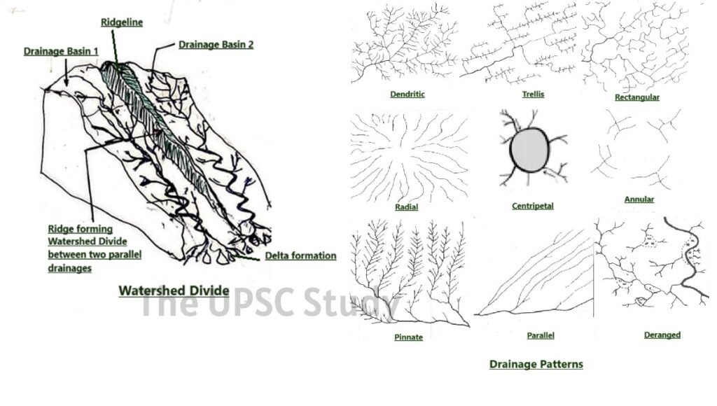
1. Dendritic Pattern
- Most common drainage pattern.
- Resembles a branching tree with tributaries joining at acute angles (<90°).
- Found in regions with uniform rock resistance with no major structural control, that is over a uniform bedrock feature.
- Found on alluvial plains and granitic or sedimentary terrains.
- Example: Ganga, Yamuna, Himalayan foothills, Deccan plateau.
2. Trellis Pattern
- Formed by long parallel consequent rivers with short subsequent tributaries joining at right angles in a grid-like network.
- Found in folded or tilted sedimentary regions, faulted structures, and cuesta topography.
- Hard rocks form ridges or escarpments which are mostly granitic and soft rocks erode to form valleys.
- Example: Chambal–Yamuna region, rift valley rivers of Vindhyan and Satpura hills, which are granitic in nature.
3. Rectangular Pattern
- Streams follow intersecting joints and faults,forming a grid-like network of right-angled bends.
- Indication of strong structural control due to jointing or faulting.
- In contrast to Trellis pattern, which too forms a grid-like network at right angle but on alternating hard and soft parallel rock layers, the rectangular pattern develops on a strongly jointed bedrock ( mostly granitic or basaltic) where streams follow faults or fractures, resulting in a blockier, rectangular grid.
- Example: Peninsular rivers like Godavari, Krishna, Cauvery. Peninsular rivers flow on basaltic bedrock.
4. Radial Pattern
- Streams radiate outward from a central elevated point such as a dome or volcanic cone.
- Typical in domal uplifts or volcanic hills.
- Example: rivers originating from Chhota Nagpur Plateau such as river Damodar; Girnar Hills of Gujarat such as river Bhadra; and Amarkanthak plateau such as Narmada, Son, and Mahanadi.
5. Centripetal Pattern
- Appear opposite of Radial pattern.
- Streams converge inwards into a central lowland or basin with interior drainage pouring into a lake (endorheic basin).
- Common in arid region.
- Example: Lower Chambal Basin, Sambhar basin in Rajasthan and the Loktak Lake in Manipur.
6. Parallel Pattern
- Streams and tributaries flow parallel to each other with tributaries joining at acute angles, due to steep regional slopes or uniform rock resistance.
- Typical in areas of cuestas or recently uplifted coastal plains.
- Example: West-flowing rivers of Western Ghats
7. Pinnate Pattern
- Develops in narrow valleys with steep flanks or ridges.
- Tributaries join main stream at acute angles.
- Example: Narmada, Upper Son
8. Annular Pattern
- Streams form concentric rings around structural domes or basins.
- Caused by alternating bands of hard and soft rock around a central structure.
- Considered a variant of trellis pattern.
- Examples: Seen in eroded domes and basins like the Nilgiri Hills.
9. Deranged Pattern
- Occurs in regions recently affected by glaciation.
- Streams flow irregularly over low-relief terrain with numerous marshes and lakes.
- Indicates poorly developed drainage after glacial retreat.
- Example: Post-glacial regions.
Conclusion:
The drainage system plays an essential role in shaping and sustaining life on Earth. From forming valleys and plains to supporting agriculture, civilisations, and ecosystems, every drainage system reflects the harmony between landforms and flowing water. The evolution of a drainage system reveals the dynamic interaction of endogenic and exogenic forces that continuously remodel the landscape. Whether through river deltas, meanders, or floodplains, each drainage system contributes to ecological balance and economic growth. Understanding the drainage system not only helps in managing water resources effectively but also deepens our appreciation of nature’s power to create, sustain, and renew life.